 A so called pilot shortage has caused smaller airlines to cancel flights and park jets, a side effect stemming from federal regulations that have dramatically increased the minimum number of flight hours required for new pilots.
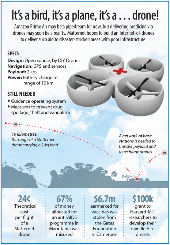
The labor shortages and service cuts have hit first and most sharply at the regional airlines that fly passengers from small airports on behalf of large carriers. One of the biggest regional carriers, Republic Airways plans to stop flying 27 of its 41 fifty seat Embraer Regional Jets because of the so called pilot shortage. That decision will lower income as much as $22 million this year. In 2010, Congress mandated that airlines’ first officers would need to hold an Airline Transport Pilot certificate–which requires at least 1,500 flight hours as opposed to the 250 hours and commercial pilot certificate previously required. The new rules, which took effect in August, came in response to the 2009 crash of a Continental Express regional flight, which investigators linked to shortcomings in the pilots’ training. VIDEO: Can You Believe These Jobs Pay This Much? Hearings on the accident also exposed to many observers—including members of Congress—the surprisingly low pay at regional airlines. The regional side of the U.S. airline industry has long been a fiercely competitive arena in which the big airlines auction large sections of their flight schedules to the lowest bidder. That’s put pressure on wages: The starting pay for a first officer at a regional airline depending on carrier is anywhere from $11,000 to $21,000 per year—about $40,000 to $50,000 lower than the same job at Delta(DAL) and United (UAL), according to the Air Line Pilots Association, the largest U.S. pilot union. And the stingy pay, in turn, exacerbates the pilot shortage. Not only does it make pilot jobs less attractive, but the small salaries also combine with the more onerous federal training rules have put many new pilots deep in debt. Paying for the necessary hours of training flights before getting a first job can cost more than $100,000. “There may be a shortage of qualified pilots who are willing to fly for U.S. airlines because of the industry’s recent history of instability, poor pay, and benefits,” ALPA President Lee Moak said last week in a statement that aimed to refute the “myth” of such a shortage. The union says that Emirates Airlines pays new first officers $82,000, “plus a housing allowance and other extraordinary benefits,” and that thousands of U.S. pilots on furlough and working abroad are “eager to return to U.S. airline cockpits—under the right conditions.” STORY: Airlines Are No Longer Losers, and Investors Have Noticed Flying cuts caused by the shortage have rippled from the tiniest of airlines to major hubs. Wyoming-based Great Lakes Airlines ended service to a half-dozen small towns on Feb. 1 after seeing its pilot ranks slashed from more than 300 to fewer than 100. United, meanwhile, explained the recent plan to shutdown its Cleveland hub in part by pointing to the inability of regional carriers to staff all of its flights there. In some cases the bigger airlines, with better salaries, are cannibalizing the lower-paid workforce of their regional partners. “Many of the mainline carriers will hire away pilots to meet their capacity needs coming at a time where the pilot pool continues to shrink,” Cowen & Co. analyst Helane Becker wrote today in a client note. “As a result of the limited pilot availability we expect to see reduced flying by the regional carriers and pilot wages increase.” The new minimum hours are coming as U.S. airlines grapple with other regulations requiring more pilot rest. The industry also has a mandatory retirement age of 65, which has caused large airlines to replace their pilot ranks by hiring from the regionals. VIDEO: America's Worst Airports: Who's Number 1? The grim outlook for regional airline profits is also showing up in their stock prices. Shares of Republic fell 8 percent today and are off almost 15 percent this year. Another large regional carrier, SkyWest (SKYW), dropped 2 percent and has declined 19 percent in 2014.  Hurricane Edouard seemed like the perfect environment to test a new data-collecting platform "DRONES" because the storm was well developed and had a well-defined eye said U.S. government scientists on Thursday.
There were four drones used for the testing called Coyotes. These drones were shaped like thin missiles with retractable wings that scissored outward and locked in position. The drones were launched via parachute into the hurricane, at a pre-programmed altitude of 3000ft the drones separated from their parachutes and commenced data collection of hurricane Edouard. Even though Edouard had 115 mph winds far out in the Atlantic. The drones collected data from parts of the storm that were too low for a hurricane hunter plane to safely fly in. Researchers had been hoping for this type of hurricane to test the drones' durability. "The stars lined up," said Joe Cione of the National Oceanic and Atmospheric Administration's Hurricane Research Division in Miami. "It was strong, we knew where it was going, we had a deployment point where we could get in and out easily." Researchers think the drones will help them better understand what makes some storms strengthen while others dissipate . Having that information while a storm is still far offshore could help officials better plan for evacuations or storm surge risks. It was the first time that the drones have been dropped into a hurricane. The 3-foot-long, 7-pound devices stayed in the hurricane for up to an hour, transmitting temperature, pressure and wind observations before falling to the ocean. The drones are covered with sensors and have a small motor on them. They are maneuvered by computer software. The drones can only be used once per hurricane hunter mission. Scientists that are a part of the aircrew also use dropsondes filled with electronics to transmit data as they fall to the ocean, but they are airborne for only a few minutes. This only provides snapshots compared to the lengthy transmissions sent back by the drones. National Hurricane Center forecasters and other scientists will spend months analyzing the data transmitted by the drones. The preliminary results were potential game changers, Cione said. One drone followed air currents through the storm. Another drone launched into Edouard's calm eye was directed into the intense eyewall in a maneuver that Cione likened to merging onto a busy highway. "There's no other device that can do that," he said by phone from Bermuda, where the drone-bearing hurricane hunter flights originated. "It orbited the eyewall, and we've never measured anything like that." Some technical kinks with the communications systems need to be worked out and funding needs to be secured before the drones can become a regular part of the hurricane hunter operations. Cione hopes to secure funding to test a few more drones next year. NOAA got a handful of the drones this year to test during the peak of hurricane season, thanks federal funding after Hurricane Sandy. On Thursday, Edouard weakened to a tropical storm as it moved into colder waters. 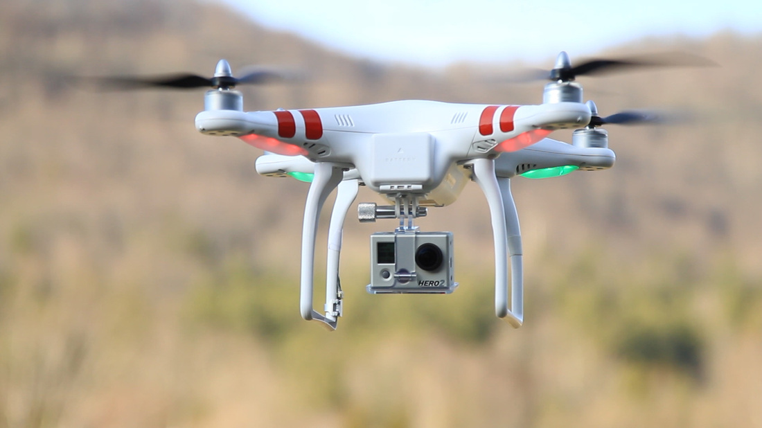 Fans reported a UFO flying over the Panthers-Chiefs preseason game, but it was later declared-identified flying object hovering over Bank of America Stadium that night.
According to Mark Washburn of the Charlotte Observer, the Charlotte-Mecklenburg Police Department said the operator of the camera-wielding drone was detained and questioned. The information they uncovered was later handed over to the FAA for further investigation. Witnesses said they saw the drone late in the game. The drone was visible until lights from a police helicopter hit it and then it disappeared behind a nearby building. While games are being played airspace over stadiums is restricted by both the NFL and the FAA. The FAA will issue TFR's (Temporary Flight Restriction Zones) over stadiums while games are being played. TFR's are among some of the most restricted airspace, to penetrate this airspace without permission holds serious consequences for the pilot involved. Often resulting in suspension or revocation of his or her pilot's license and in most extreme cases jail time. Needless to say flight of unmanned aircraft are prohibited in this airspace. A team spokesman said they weren’t aware of the drone until asked by reporters. While there was no report of charges filed, the incident represents a security breach that aviation officials need to pay close attention to.  Avgas also known as 100LL is on its way out. Numerous studies by the Environmental Protection Agency have failed to demonstrate a higher risk attributable to lead emissions by piston engine 100LL burning aircraft, lead is poisonous in any concentration. Pressure from congress is forcing the FAA to confront this issue, in hopes that a more viable fuel source will become available.
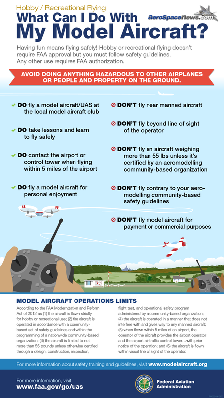
For general aviation, the problem is that many aircraft are not able to burn anything without the detonation prevention capabilities of 100LL. Nearly 30% of all piston-powered aircraft have engines that require leaded avgas. The airplanes and piston powered helicopters will need a replacement fuel that meets the anti-detonation requirements. And that also can be manufactured as well as distributed with a processes not significantly more complex than those already in place. The fact that 70% of the GA fleet can fly safely with ethanol-free unleaded auto gas better known as mogas, means that an interim solution is at hand, right now. The biggest complaint about switching to a new fuel has less to do with its manufacturability and more to do with distribution. The entire distribution system is currently set up to handle 100LL, and that’s what all the avgas tanks and trucks at airports are capable of pumping. There are some airports with mogas tanks, but these are few and far between. If and when there comes a day when the aviation industry makes the switch to an alternative gasoline product that satisfies the needs of high-power engines, the distribution system needs to be ready to handle this fuel. Suddenly switching from avgas to another type of gas won’t be simple or quick. This industry is stuck in a chicken-versus-egg conundrum. Nobody wants to invest in mogas tankage because there isn’t much of a market for mogas in aircraft. Yet the many aircraft that can use mogas have no efficient way to buy it. What should happen in order to get ready for the transition now, by installing mogas-capable facilities at airports that serve aircraft that can burn mogas. There actually is a mogas distribution network, and it is available to some degree, at only a few select airports in many states. And the more that the fuel is available, the more pilots will use it. Certainly all the pilots flying light sport aircraft thousands by some counts would welcome the opportunity to buy mogas instead of 100LL, which still causes lead-fouling on spark plugs. Airport commissions and management should have zero concern about mogas, given that its use removes lead from the environment and makes their airports greener. It’s true that many LSAs, especially those powered by Rotax engines, can burn autogas with up to 10 percent ethanol, which is what is for sale at the local gas station, but when we make the switch to a new alternative fuel, its very likely it won't contain any alcohol. There are a lot of aircraft who meet the requirements for a supplemental type certificate or STC. From organizations like Petersen Aviation and the Experimental Aircraft Association and then legally and safely burn mogas. Some aircraft with engine-driven fuel pumps such as the Piper low-wings will require a new fuel pump, but most gravity fed aircraft powered by low compression engines qualify to install the STC without modifying the fuel system. According to Petersen, about 60,000 aircraft have been upgraded with mogas STCs and 115,000 certified airplanes qualify for the STC. That doesn’t include tens of thousands of experimental airplanes with engines that could run on mogas for which an STC is not required. If mogas were more widely available, more pilots would use it. And when the inevitable transition to a new aviation gasoline comes about, the distribution network and airport facilities could be ready. Let’s start making the switch now.  Drones or Unmanned Aerial Systems (UAS) entered into American consciousness and pop culture in the last decade as they were used and deployed over war zones in Iraq and Afghanistan. Where the military used them for surveillance and strike missions to assist troops on the ground. For civilians, drones have become a widely available and increasingly common tool to record videos. Pilots of these drones also take part in something called First Person View Flights or FPV. This is when the pilot of the multi rotor flies his or her drone using goggles with a video link or a ground station with an lcd screen monitor. This let's the pilot see what the camera on the drone sees , thereby allowing the pilot to fly the drone without maintaining visual contact with the drone. This gives the pilot the ability to fly the drone as if he or she where on board flying the craft. This style of flight makes for an incredible experience while capturing incredible video. Some pilots will even go as far as to flying long distances from their launch sites. This is made possible through advances in battery technology, the right battery setup can give you an excess of 40min flight times. Some hobbyist have even figured out away to wire batteries together to give there drones an hour plus of flight time. As the hobby grows more and more people are trying to push the limits of their drones, some pilots have put together videos of their drone flying at altitudes over 3,000 feet! Recently the FAA banned flying at all national parks due to growing concerns and complaints from park attendees. In Chicago, a growing number of drone enthusiasts use the machines to showcase the city.
River North resident Matt Makris has been flying drones — or R/C aircraft, as he calls them — for about six months. He’s built two of his own, and is constructing a third. “I’ve always been interested in flight. I’ve always been interested in [remote control] planes and helicopters,” he said. “From there, my interest keeps evolving, and I wanted to learn more.” His favorite place to fly his aircraft is near the former Cabrini-Green public housing project, where his videos have captured the eeriness of abandoned row houses and rusting basketball hoops. “Half of the fun for me … is making [drones] and learning about radio frequency, voltage, electricity, learning how electronics work,” said Makris, co-founder of River North digital marketing agency EM Search Consulting. Regulating drones: a work in progress The images caught by area drone videographers are worthy of Hollywood. They are also potentially dangerous and possibly violate guidelines set by the FAA in 1981, said Matt Waite, director of the Drone Journalism Lab at the University of Nebraska-Lincoln. The guidelines include alerting airports if a drone is flying within five miles, not flying over groups of people and not flying above 400 feet, Waite said. "In Chicago [flying drones] is a real problem ... because you have an exceptionally busy airspace," Waite said, especially when it comes to police helicopters and air ambulances. Also problematic are the crowded areas and the allure of skyscrapers that draw photographers. Aurora resident Skip Signhsumalee shot stunning video of the city, but federal guidelines warn of flying too high. But in their quests to capture remarkable imagery, drone enthusiasts have to balance these guidelines with laws that are “at best murky and at worst, there are no rules,” Waite said. “The controversy here is that the FAA has been using those voluntary restrictions and some other parts of the law that may or may not apply to small flying robots with cameras on them,” Waite said. The FAA declined to comment, but said in a statement it expected to unveil updated guidelines for drone amateurs later this year. The agency said drones fall under its purview as aircraft, and pointed to a June news release alerting drone enthusiasts to updated guidelines. “We have a mandate to protect the American people in the air and on the ground, and the public expects us to carry out that mission,” FAA Administrator Michael Huerta said. The news release from Huerta added that the FAA may take action against users whose aircraft “[endanger] the safety of the national airspace system.” The guidelines also state drones cannot be used for commercial purposes. The FAA has signaled a willingness to target drones being used for commercial use, Waite said, though courts have ruled in favor of at least two defendants fined by the FAA. “Right now, if you’re a hobbyist, you’re just doing it for fun, not getting paid…then you’re cool,” Waite said. Those hobbyists pay a steep price for their gear. Makris said his custom machines can cost up to $2,000. Roman estimated his drone — which includes added features like a GoPro camera and kit that allows him to view the drone's perspective on a mobile device — cost about $1,500. "It's an expensive hobby," Roman said. "You start losing track once you start getting into it." No one knows for certain how many drone enthusiasts are in the city. A MeetUp.com group called the Chicago Area Drone User Group boasts more than 100 members, many of whom live in the suburbs. Economic drivers or flying spies? Ryan Twose, a Deerfield resident who is the group's administrator, said drones could be used for more than just hobby photography. "It's an exciting technology. I think robotics and unmanned systems in general have come a long way," he said. "It's a great emerging technology that could positively impact the economy in a lot of ways." Amazon and Google, among other companies, have floated the idea of using drones to deliver products, but that's likely a long way off, Waite said. The onslaught of tiny aircraft in the skies brings concerns ranging from privacy and safety to how law enforcement uses the technology. Last year, the General Assembly banned the use of drones by law enforcement agencies to collect surveillance. The Freedom from Drone Surveillance Act includes caveats that drones may be deployed to combat an immediate criminal or terror threat, or if a judge approves a search warrant. Unlike the drones that fly over Afghanistan and Pakistan, the state bans law enforcement agencies from arming their devices. The Chicago Police Department did not respond to questions regarding whether it owns drones, or if it had used the technology before. All the drone users interviewed for this article acknowledged the privacy concerns created by drones, which can hover hundreds of feet in the air. But they said those fears are misplaced. "By and large, the overwhelming vast majority of these things are flying for fun," Waite said. "They're not spying on you." For now, it appears that the skies are open for drone enthusiasts. “You’re going to see more and more people flying these things in parks, buzzing on the street in your neighborhood,” Waite said.  Attendance at the World's greatest aviation event AirVenture earlier this month showed a sharp spike, the flight training industry is also enjoying a tremondous growth spurt through the first part of 2014. According to an informal survey of more than a dozen flight schools across the country conducted by AVweb this month, all report increased training activity beyond the usual seasonal enrollment. "The increase in enrollment picked up drastically during the month of April. And then started to slow down a little, but that's okay. We had more students than we could really handle," said Christa Holden, who manages Haps Air Service in Ames, Iowa.
We heard similar reports from other parts of the country, including the Pacific Northwest, where weather often conspires to keep training flights grounded. But not this summer. "Actually, we have more students than we have instructors right now. We're all flying the full eight hours about every day," said Doug O'Donnell, a CFI at Avian Flight Center, near Bremerton, Washington. Eleven hundred miles down the coast at Santa Paula, California, Judy Phelps said CP Aviation is also experiencing consistent demand. "I wouldn't say we're up or down. The problem I find is that we have all the airplanes and all the instructors decide to take off the same weekend and now you have all the airplanes sitting with no instructors. It's hard to find good instructors and keep them around," Phelps told us. What's going on? Some schools think the training surge is due mostly to the economy, but some are noticing a demographic bubble, too. "I think everybody is realizing the economy is not going to tank and they're sitting on some cash savings and they're spending. A lot of our clients own businesses and they're reasonably successful," says Cody Pierce of Aces High Aviation in Long Beach, California. He says many of his customers are from the entertainment industry, where high salaries support the flying habit. While the schools were surveyed report 20-somethings in the new-student mix, they're seeing more financially secure empty nesters or middle-aged career people. "The guy I love to see coming through the door is someone who says, 'I took a few lessons back in my 20s and my kids are in college now, so I decided I want to go back to it.' Love that guy," says Larry Sidle, who operates Beaver Valley Aviation near Dayton, Ohio. He flies both Cessna 152s and 172s, as do many of the schools we surveyed. A few are also operating LSAs with varying degrees of success, but older Cessnas remain the bedrock of U.S. flight training. Among the schools that were surveyed who operate Cessna 150s or 152s, the average hourly rental rate is $97. For 172s, the average was $124 per hour for what many in the industry call "classic models," mid-1970s to mid-1980s aircraft with steam gauges. We found a smattering of flight schools operating newer G1000 Cessna 172s, at an average rental rate of about $155. Most of those aircraft are 2005 or 2006 models because flight schools say anything newer is too expensive to insure and thus too expensive to operate. The schools were polled on their views toward new or refurbed trainers and I'll have an additional blog on that later. While flying skydivers on one beautiful fall day in Upstate New York, I was tasked with transporting one of our aircraft to maintenance. What was supposed to be a routine quick 35 min flight from Saratoga NY to Hamilton NY quickly turned into the longest hour of my life. I was one of the those pilots who put all of his faith and trust into a GPS system, trusting that it would never fail.
The flight started out great I was cleaning up my flaps and departing the pattern to the west. When all of a sudden shortly after takeoff my GPS posted an alert NO RAIM AVAILABLE!!! OH NO!!! What am I going to do now?! Initially I thought no problem I will land at our primary airport/Drop Zone which was located halfway to Hamilton NY so I could troubleshoot, regroup, and re-plan. So I decided to whip out my sectional chart, plotter, & E6B. I found where I was on the sectional plotted a new course and began to use basic pilotage and little bit of dead reckoning to locate the airport. I knew if I could keep Schenectady County Airport to my right and Albany Int'l to my left, I could find my home airport in the middle. I passed between the two airports at 6500ft and could not get eyes on my home airport I flew zig zag patterns east to west searching for the airport. After all of that spur of the moment planning I was officially lost in the air. I couldn't believe it, thoughts of my flight instructor telling me to always have a back up for my primary nav aid popped into my head. "Backup the GPS with the VOR and backup the VOR with your planned route on your sectional. Constantly find where you are on the sectional, you can never have too many backups while flying redundancy will keep you alive". After coming to the realization that I was lost, I swallowed my pride and contacted Albany approach. I admitted to being lost and needing help, they provided me with vectors and I found my way home. I landed and got myself together, planned a new flight, and I made it to Hamilton without the use of a GPS. Develop Basic Navigation Skills While flying confirm your position using visual cues, land based navigation aids, and dead reckoning(Slowly becoming a lost art in the world of aviation!!!). Practice flying with the GPS as the backup or secondary form of navigation instead of it being your primary navigation aid. If you are using GPS as the primary form of enroute navigation, you can use VOR's and ground based navigation aids when available to provide a backup to GPS or other RNAV information. Think "DAD" & Green Data Always know your heading, altitude, and distance to the desired fix. Think "DAD": distance, altitude, and direction. If the GPS fails or you have trouble entering information, you can quickly revert to primary methods of navigation and maintain your course through flying your known heading. Airline pilots call this "flying green data". Prepare a head of time & Practice the full approach Be fully aware of the environment you are going into. Give yourself enough time to become familiar with the approach and notify ATC if you are unable to safely proceed due to unexpected changes with an enroute clearance or approach clearance. Pilots become accustomed to flying instrument approaches through radar vectors. You should be confident in flying without air traffic control vectors. Practice flying green data and full approaches without the vectoring assistance of air traffic control. While we plan our flights we encounter information that could affect the outcome of that flight. How you manage that flow of information will definitely have an effect on the relative success or failure of each and every flight. The first step of ADM is to gather information from all available sources. Doing that is known as the perceive (Perception) part of the process. You can think of the term "information" as situations or facts that require your attention. You will want to perceive situations or facts related to each critical element of your flight. There is a great acronym to help you figure out what those elements are called PAVE.
Pilot, passengers and other people involved. Aircraft you will be flying. enVironment in which you will operate (airspace, airport, weather). External pressures likely to influence your decision making process. Step two of ADM would be to process the information that you perceived in step one. As you receive information, it is then filtered through all five the senses: sight, sound, smell, touch, and taste. Note: that not all of the information will make it through our filtration system. You might not hear something correctly, or some of the errors prevalent in human decision making might come into play. When we process the information we perceive, the goal is to organize the information, interpret it, and try to match the alternatives with situations from your experience. A structured way to organize all of this information is to process it with CARE: Consequences of each hazard associated with the PAVE elements. Alternatives available. Reality of the situation or hazard. External pressures that might influence your analysis. The third step of the ADM process is Performance. How you perform will be based on the perception and processing you did in the first two steps. At the most basic level, you perform in one of two ways: action, or inaction. As you noticed in step one and step two, there are a lot of external pressures on the human decision making process. These influences may directly or indirectly affect the action or inaction you choose, and also affect how quickly and how decisively you perform. In addition, the action or inaction comes from how accurately you perceived and processed the information up to this point in time. At the performance stage, you should think about M.E. Mitigate or Eliminate the hazard(s) and risk that you perceived and processed. The relative success or failure of the flight - maybe even the life or death moment - may hinge on how well you have perceived, processed, and performed in the ADM process. The fourth step in the ADM process is evaluation. Constantly think about the outcome of every decision that you make. Be judicious and think about your actions at every step, and then start the process all over again. Remember the three P’s: Perceive, Process, & Perform. A good example of ADM would be a consistent instrument scan in instrument meteorological conditions (IMC), briefing the approach, tuning in the proper frequencies, and staying ahead of the aircraft. The ADM process starts at the preflight and should not stop until your airplane is parked, shut down, and securely tied down. In order to properly plan a flight, you will need to be able to determine how far? How fast? How long? Direction of flight (True Course), and how much fuel you will consume for each leg of your route. This can be accomplished by using a course plotter and an E6B Flight Computer. Draw the course on an aviation sectional chart and lay the plotter along the course line. Measure the distance, being careful to use the proper scale on the plotter. Use the plotter to determine the true course by aligning the center hole on the protractor portion of the plotter with a line of longitude or latitude on the chart, and reading the course from the proper scale on the protractor. Use your common sense to double check your results!!! – do your results make sense based on an estimate of the direction you will be heading?
You would be surprised how many errors could be caught and corrected by comparing the answer to a rough estimate to see if it makes sense! Practice using the plotter to get a True Course from a sectional by making up arbitrary routes between points and measuring the distance and course between them until you are comfortable that you can get the correct information quickly and accurately. Note the course and distance information on a notepad, you will need to figure out where your top of climb and top of descent points will be along your flight path. When traveling cross country, we make our plan to fly at certain altitudes depending on the terrain we need to pass over and, in the case of a VFR flight, the VFR cruising altitude requirements for easterly courses odd altitudes plus 500 feet or westerly courses even altitudes plus 500 feet when above 3000 feet above the ground AGL. Altitudes on maps, and in Area Forecasts and Winds Aloft Forecasts are given as height above mean sea level MSL and you will plan to fly your route at a MSL altitude. Altitudes for cloud layers in Terminal Forecasts and METARS are given in distance above ground level or AGL, so you must add the airport elevation to AGL altitude to get the cloud level relative to MSL. A scrupulous pilot always considers where they would land in the event of an engine failure or other major problem. According to the Pilot Information Manual for a Cessna 172N, the plane will descend at about 675’ per mile at best glide speed, for example descending from 8000’ to 4000’ in 6 miles. Ask yourself as you pick your route, could I glide to some place where I could land and survive from any point along my route? If not, you may want to consider other options! The regulations specify that one must fly at least 1000’ over a congested area, 500’ over a ‘non-congested area’ and at least 500 feet away from any person, vehicle, vessel or structure in sparsely populated areas. When planning a cross country trip it makes good sense to adopt the more conservative IFR terrain clearance standards of at least 1000’ above the ground and 2000’ above mountainous areas. When it is windy and you are flying over mountains an even greater clearance is desirable, both to get further away from turbulence caused by the winds flowing over the terrain irregularities and as an extra margin of space between yourself and the ground in the event that strong downdrafts are encountered. Navigation today for most commercial flights is much easier than 20 years ago and it is due to upgrades in weather detection equipment on the ground and in the aircraft. During the years of flight before digital weather radar, thunderstorm avoidance prior to departure was accomplished by a pilot plotting known thunderstorms forecast activity on a map and either planning the route or verifying the route planned by the airline dispatcher avoided those thunderstorms.
The location of the thunderstorm cells and the route of flight were updated continuously after takeoff in order to continue avoiding the areas of bad weather. Approach Control was also able to vector or assist the aircraft in avoiding bad weather but the ultimate responsibility was the responsibility of the aircraft crew. The aircraft crew also maintained radio contact with their dispatcher who had access to numerous resources to continually update the crew and modify the flight route to maintain a route that best avoided thunderstorm activity. Today the process is very similar however current generation aircraft have much better on board digital weather radars and flight navigation displays that allow the pilots to see how the weather affects their current route of flight. It gives them the “Birds Eye View” depiction. It also displays the winds and temperatures at altitude allowing the flight crew to continually monitor and adjust their flight plan and route of flight to provide the best ride available to the passenger. Even though the thunderstorms can be avoided it is not always possible to avoid all the minor turbulence that is produced by the thunderstorms, jet stream winds aloft and other factors. A GPS receiver is able to determine its own position by using the distance between itself and multiple GPS system satellites. GPS receivers performs a calculation similar to how you would determine your position using the DME distances to several locations. GPS performs this calculation called multilateration automatically from at least four space based stations otherwise known as satellites out of the available constellation of 24 or more satellites.
Under ideal conditions, the GPS may determine your position within 50 feet or less. In addition to accuracy, the biggest advantage to using satellites instead of ground based stations is that there is no need to be within a certain distance or in a line-of-sight position to a station on the ground, so that navigation information is available almost anywhere in the world with a view of the sky. While the satellite signal is not affected by clouds or other weather phenomenon, satellites low on the horizon may be blocked by mountains or other terrain. In addition to the ability to calculate position, a GPS receiver typically has a range of other functionality which allows it to calculate information such as the direction of movement and speed. By incorporating a database of airports and other ground locations called waypoints a GPS can also provide navigational information relative to these points. Some GPS receivers also include terrain maps and other information which can be overlaid with the position, course of the aircraft and selected waypoints. Different types of GPS receivers are available for aviation use, ranging from simple hand-held devices to panel mounted units with large map display screens. GPS receiver installations may also be approved for IFR use or limited to use as an aid to navigation and situational awareness under VFR. WAAS GPS receivers include additional capabilities to allow for precise horizontal vertical guidance during IFR precision approach procedures. IFR approved GPS receivers include the ability to automatically monitor system availability and reliability and to alert the pilot when the navigation information may not be reliable. This feature is called RAIM, or Receiver Autonomous Integrity Monitoring. VFR only GPS receivers may not include this capability – it is important to know whether it is a feature of the GPS you are using, and to cross-check the navigation information provided by the GPS for VFR use with other sources, such as VOR stations and landmarks on the ground. Another consideration is to insure that the GPS database is up to date. Most GPS receivers display the database expiration date as part of the power up process. Airspace, airport and waypoint information change on a regular basis and most aviation GPS receivers can be kept current with subscription database updates. If the database is not current, information on special airspace and other important navigation information may not be correct, leading the pilot to possibly enter restricted airspace or to navigate incorrectly. If an out-of-date GPS database is in use, it is imperative that the pilot cross check the information provided by the GPS with other sources such as current sectional charts. Each make and model of GPS receiver has different functionality and different means of accessing its features. So it is essential to have an operating manual available for the specific unit you will be using, particularly if you plan to use it for navigation purposes on a cross-country flight. |
Brian JohnsonI am a philomath when it comes to aviation, and I want to impart my knowledge to others. I LOVE TO FLY!!! Get your Pilot Gear here:
Archives
January 2015
Categories |

 RSS Feed